Drone Surveys in Harrow
At KEYS Consulting Ltd, we combine aerial inspection technology with chartered surveying expertise to deliver clear, actionable insights for homeowners, landlords, and commercial clients. Our drone surveys in Harrow provide a fast, accurate, and non-intrusive way to assess property conditions, especially where access is difficult or risk is high.

- Safe inspections without the need for scaffolding or invasive access
- Fast turnaround with minimal disruption to your property
- High-resolution aerial imagery for accurate defect identification
- Clear, easy-to-understand reports with actionable next steps
- Ideal for roofs, elevations, and hard-to-reach structures
- Suitable for homeowners, landlords, and commercial clients
Comprehensive Aerial Surveying Services
Our service supports every stage of property inspection, maintenance, and acquisition. Whether you are assessing condition, investigating defects, or planning works, aerial inspections provide clarity, speed, and safety.
We specialise in:
- Roof and elevation inspections
- Pre-purchase aerial inspections
- Defect identification and condition reporting
- Planned preventative maintenance inspections
- Structural and façade assessments
Each survey is carried out by experienced professionals, combining aerial data with technical surveying expertise.
Understanding potential liability is critical when dealing with Dilapidations Claims.
We prepare cost assessments using:
- BCIS Online data
- Competitive tender returns
- Invoices from completed remedial works
- Recent market evidence
Repair standards, reinstatement clauses and statutory limitations such as Section 18 of the Landlord and Tenant Act 1927 are carefully considered. This ensures that claims reflect genuine financial loss rather than theoretical repair costs.
Where refurbishment or redevelopment is proposed, we assess how this impacts quantum and negotiation strategy.


Pre-Inspection Drone Surveys for Property Purchases
Drone property surveys play a valuable role before purchasing a property, particularly where roof condition or structural access is limited.
We assess:
- Roof coverings, chimneys, and flashing
- Guttering and drainage systems
- External elevations and high-level defects
- Signs of water ingress or deterioration
This allows buyers to understand risks and potential costs before committing. You can also explore our wider building surveying services for a complete property assessment approach.
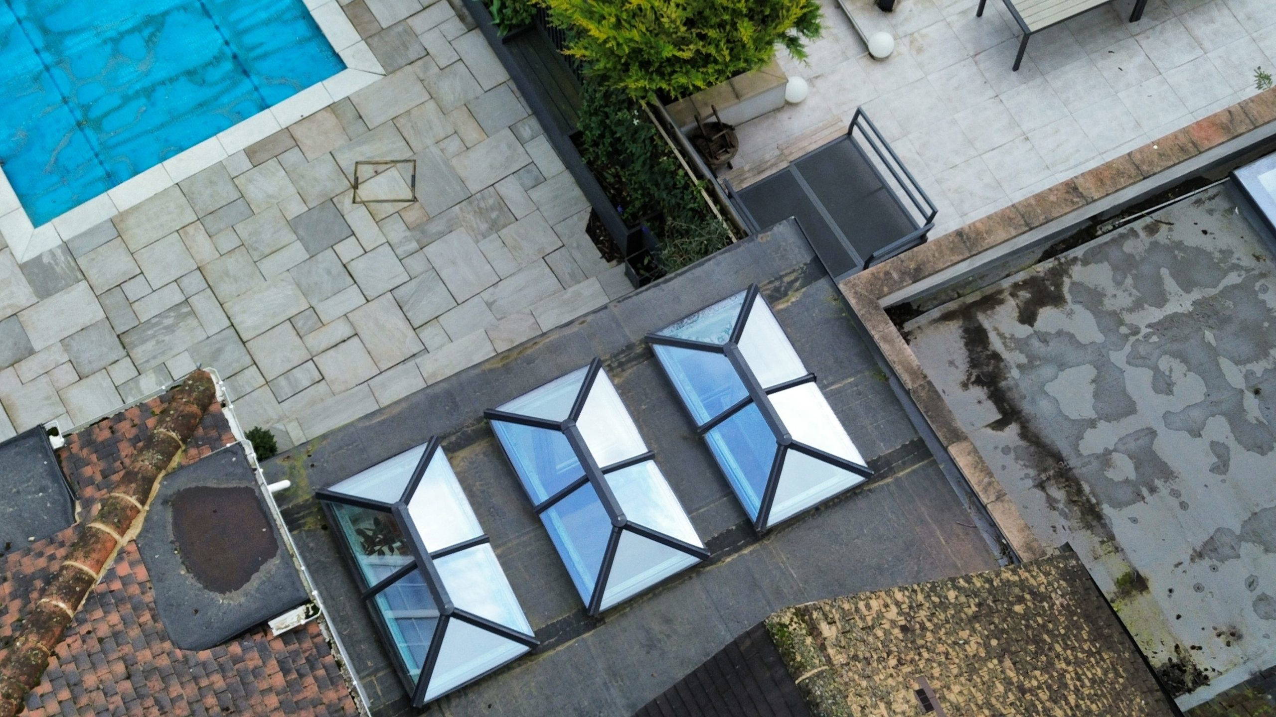
Roof & High-Level Condition Surveys
Roof defects are one of the most common and costly issues in property ownership, yet they are often difficult to inspect safely.
Drone roof surveys provide:
- Close-up imagery of tiles, slates, and membranes
- Identification of cracks, displacement, or wear
- Inspection of chimneys, parapets, and roof junctions
- Assessment of flat roofs and drainage performance
This approach enables early detection and targeted repairs, reducing long-term costs and disruption.


Technical Aerial Inspections & Defect Analysis
This service is used to support detailed defect investigations where traditional access is limited.
We identify issues such as:
- Structural movement and cracking at height
- Damp penetration points and failed detailing
- Roof membrane failure or ponding water
- Deterioration of external finishes
Findings can be integrated into our defects analysis services for deeper investigation and remedial planning.
Planned Preventative Maintenance (PPM) Inspections
Drone surveys are an effective tool for long-term asset management.
We provide drone inspections to support:
- 5 and 10-year maintenance planning
- Budget forecasting for repairs
- Ongoing condition monitoring
- Portfolio management for landlords and investors
This service complements our planned preventative maintenance strategies, helping property owners maintain value and avoid unexpected costs.


Supporting Broader Property Consultancy Services
Data captured through our aerial survey services can be integrated with a wide range of professional services, ensuring a complete understanding of your asset.
These include:
- Residential surveys for homebuyers
- Commercial surveys for investors and businesses
- Project management for refurbishment or development works
- Dilapidations advice for lease obligations
This joined-up approach ensures your findings translate into practical, actionable decisions.
Why Choose KEYS Consulting Ltd
- RICS Chartered Surveyors and Chartered Building Engineers
- Over 35 years of professional experience
- Proven expertise across residential and commercial property
- Integration with wider surveying and consultancy services
- Clear, transparent reporting and practical advice
- Trusted across Harrow and North West London
Learn more about our experience on our About Us page.

Areas We Cover
We provide drone property surveys in Harrow and surrounding locations, including:
- Watford
- Stanmore
- Northwood
- Ruislip
- Borehamwood
- St Albans
Our local expertise ensures accurate assessments tailored to regional property types and conditions.
Frequently Asked Questions
What is a drone survey for property inspection?
A drone survey uses aerial technology to inspect roofs and elevated areas, capturing detailed imagery without the need for physical access.
Are drone surveys safe and compliant?
Yes. All surveys follow UK aviation regulations set by the Civil Aviation Authority.
Can this service replace a building survey?
No. It complements traditional surveys by providing additional visual data, particularly for hard-to-reach areas.
How quickly can a survey be completed?
Most inspections are completed within a single visit, with reporting provided shortly afterwards.
How much does a drone survey cost?
Drone survey costs vary depending on the size of the property, complexity, and level of detail required. For an accurate price, it’s best to request a tailored quote based on your specific needs.
Book Your Drone Survey in Harrow Today
For professional drone surveys, contact KEYS Consulting Ltd today. Our expert surveyors will assess your property using advanced aerial technology and deliver a clear, accurate, and actionable report.